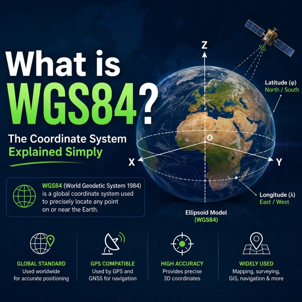
WGS84 (World Geodetic System 1984) is the global standard coordinate system used by GPS satellites, digital maps, and virtually all geospatial software. It defines every location on Earth using latitude, longitude, and height measured against a mathematically modeled ellipsoid a slightly flattened sphere that best approximates the shape of our planet. If you have ever seen coordinates like 29.9792° N, 31.1342° E, those numbers are expressed in WGS84.
Why WGS84 Matters; Where It Is Used
WGS84 is not just a technical standard tucked away in textbooks. It underpins almost every tool that tells you where something is on Earth.
GPS and Smartphones
Every consumer GPS device from your phone’s navigation app to a dedicated Garmin unit outputs coordinates in WGS84. When Google Maps pins your location, it is using a WGS84 latitude and longitude under the hood. The same is true for fitness trackers, drone autopilot systems, self driving car positioning, and aviation navigation.
Satellite Imagery
Remote sensing datasets from Sentinel-2, Landsat, MODIS, and most other earth observation satellites are referenced to WGS84. When you load satellite imagery into QGIS or ArcGIS, the default coordinate reference system is almost always WGS84 (EPSG:4326). This makes it easy to overlay data from different sensors without reprojection errors.
Web Maps
OpenStreetMap, Google Maps, Mapbox, and Leaflet all store and serve geographic data in WGS84. The standard web tile system (used by virtually every web mapping platform) is built on a projection called Web Mercator, which itself uses WGS84 as its underlying datum.
The GeoJSON Standard
If you work with spatial data in any programming context, you have almost certainly encountered GeoJSON. The GeoJSON specification (RFC 7946) mandates WGS84 no other coordinate system is permitted in a compliant GeoJSON file. This makes WGS84 the de facto standard for spatial data exchange in web development, APIs, and data pipelines.
How WGS84 Actually Works
Understanding WGS84 properly requires answering one question first: why do we need a coordinate system at all?
The Earth is not flat, and it is not a perfect sphere. It bulges slightly at the equator and is flattened at the poles. This irregular shape makes defining “where am I?” surprisingly complex. WGS84 solves this by building a precise mathematical model of the Earth’s shape and then anchoring a coordinate grid to it.
The Earth Isn’t a Perfect Sphere: The Ellipsoid Model
WGS84 models the Earth as an ellipsoid: a sphere that has been slightly squashed from top to bottom. The specific parameters are:
- Semi major axis (equatorial radius): 6,378,137 meters
- Flattening: 1/298.257223563
This ellipsoid is not just an approximation it is an extremely accurate one, refined over decades using GPS satellite measurements. It forms the geometric foundation that WGS84 coordinates are built upon.
Latitude, Longitude, and Ellipsoidal Height
Once the ellipsoid is defined, positions can be described with three values:
- Latitude (φ): The angle north or south of the equator, ranging from −90° (South Pole) to +90° (North Pole).
- Longitude (λ): The angle east or west of the Prime Meridian (Greenwich), ranging from −180° to +180°.
- Ellipsoidal height (h): The vertical distance above the surface of the WGS84 ellipsoid.
One important nuance: ellipsoidal height is not the same as elevation above sea level. The WGS84 ellipsoid does not follow the ocean surface it passes above or below it depending on location. The difference between ellipsoidal height and sea level can be as large as ±100 meters in some parts of the world. Converting between the two requires a separate geoid model such as EGM2008.
What EPSG:4326 Means
You will often see WGS84 referred to as EPSG:4326 in GIS software, APIs, and data files. These are two names for the same thing.
EPSG stands for the European Petroleum Survey Group, which created a registry of standardized codes for coordinate reference systems. EPSG:4326 is simply the registry code assigned to the WGS84 geographic coordinate system. When your GIS tool asks you to choose a CRS and you select EPSG:4326, you are selecting WGS84.
Think of it this way: WGS84 is the name of the standard; EPSG:4326 is its ID number in the global registry.
WGS84 vs UTM — Which Should You Use?
WGS84 and UTM (Universal Transverse Mercator) are often confused, but they serve different purposes and are not mutually exclusive.
WGS84 is a geographic coordinate system. It describes positions on a 3D ellipsoid using degrees of latitude and longitude. It is global, consistent, and ideal for data storage, GPS output, and any task where you need worldwide coverage.
UTM is a projected coordinate system. It takes the curved surface of the WGS84 ellipsoid and flattens it into a flat 2D grid, expressed in meters. This makes it far more suitable for measuring distances and areas accurately within a local region.
| WGS84 | UTM | |
|---|---|---|
| Units | Degrees | Meters |
| Coverage | Global | Regional (60 zones) |
| Best for | GPS data, data storage, global maps | Distance/area calculations, local surveys |
| Distortion | None (3D model) | Increases away from zone center |
The key insight: UTM is built on top of WGS84. UTM zones are projections of the WGS84 ellipsoid. So the two systems are not competing they work together. You store data in WGS84 and project to UTM when you need accurate metric measurements.
For a deeper comparison of when to use each system, see our full guide: Coordinate Systems Explained: WGS84 vs UTM.
WGS84 in QGIS and ArcGIS
In practice, most GIS users encounter WGS84 directly through their software. Here is what it looks like in the two most common platforms.
QGIS
When you create a new QGIS project or load a dataset, the CRS shown in the bottom right corner is usually EPSG:4326 — WGS 84. QGIS uses this as its default unless you change it.
To set your project CRS to WGS84 explicitly:
- Go to Project → Properties → CRS
- Search for EPSG:4326
- Select WGS 84 and click OK
When reprojecting a layer to WGS84 for export:
- Right-click the layer → Export → Save Features As
- Under CRS, select EPSG:4326
- Save as GeoJSON, Shapefile, or your preferred format
ArcGIS Pro
In ArcGIS Pro, WGS84 appears under Geographic Coordinate Systems → World → WGS 1984. Its WKID (well-known ID, ArcGIS’s equivalent of the EPSG code) is 4326.
To set a map’s coordinate system:
- Open Map Properties → Coordinate Systems
- Search for WGS 1984
- Select it under Geographic Coordinate Systems
For field calculations or geometry tools that require metric distances in ArcGIS, you will want to project your data to a WGS84-based UTM zone before running the analysis.
Common Questions About WGS84
Is WGS84 the same as GPS?
Not exactly but they are tightly linked. GPS satellites broadcast their orbital positions using WGS84 as the reference frame. So when your GPS receiver calculates your location, the output is a WGS84 coordinate. However, GPS is a positioning technology and WGS84 is a coordinate standard. GPS can technically work with other datums, but WGS84 is by far the most common.
Is WGS84 the same as EPSG:4326?
Yes. EPSG:4326 is simply the numeric code used to identify WGS84 in the EPSG geodetic registry. When GIS software, APIs, or data files refer to EPSG:4326, they mean the WGS84 geographic coordinate system. The two terms are interchangeable in everyday GIS work.
What is the difference between WGS84 and NAD83?
Both WGS84 and NAD83 (North American Datum 1983) use very similar ellipsoids and were aligned to within about 1 meter when they were created. For most practical GIS work, the difference is negligible. However, NAD83 is fixed to the North American tectonic plate, while WGS84 is Earth centered and shifts slightly relative to any given plate. Over time, the two have diverged by about 1–2 meters depending on location. For high-precision surveying in North America, this matters. For web mapping and general GIS work, the two are effectively interchangeable.
Can I measure distances in WGS84?
Not directly. Because WGS84 uses degrees as its unit, a “one degree” step covers very different ground distances depending on where you are on the Earth. At the equator, one degree of longitude is about 111 km. Near the poles, it approaches zero. To measure accurate distances or calculate areas, you need to project your WGS84 data into a projected coordinate system like UTM, which uses meters. Most GIS tools will warn you if you try to run a distance or area calculation on an unprojected WGS84 layer.
Why do my GPS height values differ from elevation on a map?
This is one of the most common sources of confusion in GIS. GPS devices report ellipsoidal height the distance above the WGS84 ellipsoid surface. Maps and elevation datasets typically use orthometric height the distance above the geoid, which approximates mean sea level. The difference between the two (called geoid undulation) varies by location and can reach ±100 meters. To convert GPS ellipsoidal heights to meaningful elevation values, you need to apply a geoid correction using a model like EGM2008 or EGM96.
Key Takeaways
WGS84 is the invisible backbone of modern geospatial technology. It defines the mathematical model of the Earth that GPS satellites use, gives every point on the globe a consistent latitude/longitude address, and serves as the default coordinate reference system for satellite imagery, web maps, GeoJSON files, and GIS platforms worldwide.
Whether you are a GIS analyst, a remote sensing specialist, or just getting started with spatial data, understanding WGS84 is foundational. The main points to remember:
- WGS84 uses latitude and longitude in degrees, referenced to a precise ellipsoid model of the Earth.
- Its EPSG code is 4326 used interchangeably in software and APIs.
- It is global and consistent, making it ideal for data storage and GPS output.
- It is not designed for distance or area measurements use UTM for that.
- Ellipsoidal height (from GPS) and elevation above sea level are not the same thing.
Want to go deeper? Read our full guide on WGS84 vs UTM: When to Use Each Coordinate System to understand how the two systems work together in real GIS workflows.