Geographic Information Systems (GIS) have become one of the most powerful technologies for managing, analyzing, and visualizing location based data. From urban planning and environmental management to disaster response and business intelligence, GIS helps organizations make smarter decisions by understanding spatial relationships.
But what exactly makes a GIS work?
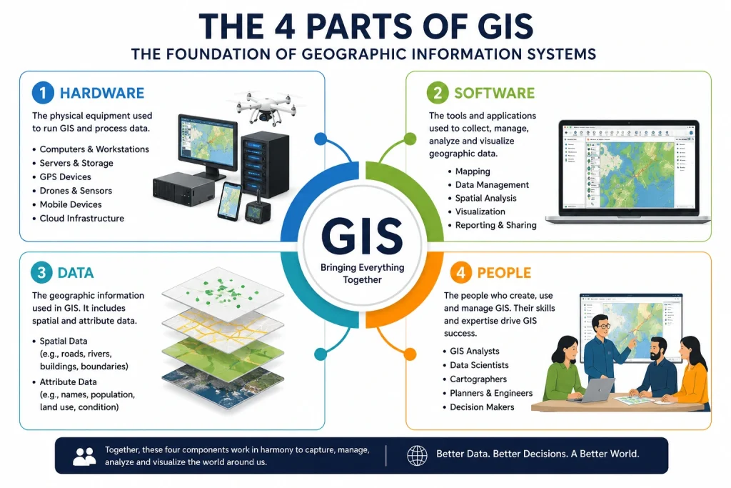
If you’re new to geospatial technology, one of the first concepts you’ll encounter is the 4 parts of GIS. These four components work together to collect, process, analyze, and present geographic information effectively.
In this guide, we’ll explore each component in detail, explain why they matter, and show how modern GIS platforms continue to evolve in 2026.
Understanding GIS
A Geographic Information System (GIS) is a framework that combines hardware, software, data, and people to capture, manage, analyze, and visualize geographic information.
Every map you create, every spatial analysis you perform, and every location-based decision you make relies on these core components functioning together.
Without any one of them, a GIS cannot operate efficiently.
The 4 Parts of GIS
1. Hardware
Hardware refers to the physical equipment used to run GIS applications and process geographic data.
Examples include:
- Desktop computers
- Workstations
- Servers
- GPS devices
- Drones
- Mobile devices
- Data storage systems
- Cloud infrastructure
Modern GIS workflows often require powerful computing resources, especially when working with:
- Satellite imagery
- LiDAR datasets
- 3D city models
- Machine learning applications
- Real time sensor data
In 2026, cloud computing has become a critical part of GIS hardware infrastructure, allowing organizations to process massive datasets without maintaining expensive on premise servers.
Why Hardware Matters
The quality of your GIS analysis often depends on your computing capabilities. Slow hardware can significantly affect data processing, rendering, and analytical performance.
2. Software
Software is the engine that powers GIS operations.
GIS software enables users to:
- Create maps
- Store spatial data
- Perform analyses
- Visualize results
- Share geographic information
Popular GIS software includes:
- ArcGIS Pro
- QGIS
- Global Mapper
- MapInfo Pro
- GRASS GIS
These tools provide various capabilities for spatial analysis, cartography, remote sensing, and database management.
Best GIS Software 2026
As GIS technology evolves, professionals continue searching for the most efficient tools available.
For a detailed review of the latest GIS platforms, read our comprehensive guide:
You can compare features, pricing, strengths, and ideal use cases for each platform before making a decision.
3. Data
Data is often considered the most valuable component of any GIS.
A GIS is only as good as the data it contains.
GIS data generally falls into two categories:
Spatial Data
Spatial data represents geographic locations and features.
Examples include:
- Roads
- Buildings
- Rivers
- Administrative boundaries
- Land parcels
Attribute Data
Attribute data provides descriptive information about spatial features.
For example:
| Feature | Attribute |
|---|---|
| Building | Height, owner, construction year |
| Road | Name, speed limit, surface type |
| River | Length, water quality, flow rate |
Common GIS Data Sources
- Satellite imagery
- GPS surveys
- Drone mapping
- Government datasets
- OpenStreetMap
- Remote sensing products
- Field data collection
Organizations increasingly rely on high resolution and real time datasets to improve operational decision-making.
4. People
Many beginners assume GIS is purely about technology.
In reality, people are the most important part of GIS.
Without skilled professionals, GIS software and data have little practical value.
GIS professionals include:
- GIS Analysts
- GIS Specialists
- Cartographers
- Surveyors
- Remote Sensing Experts
- Urban Planners
- Environmental Scientists
- Data Scientists
These experts design workflows, perform analyses, interpret results, and communicate findings to stakeholders.
Why People Matter
People provide:
- Critical thinking
- Analytical skills
- Decision making capabilities
- Domain expertise
- Problem solving abilities
As artificial intelligence becomes more integrated into GIS workflows, human expertise remains essential for interpreting results and ensuring data accuracy.
How the Four Parts Work Together
The four components of GIS are interconnected.
Consider a city planning project:
- Hardware provides the computing infrastructure.
- Software performs mapping and analysis.
- Data supplies information about roads, buildings, and land use.
- People interpret results and make planning decisions.
If any component is missing, the project’s effectiveness decreases significantly.
Comparing the Best GIS Tools
Choosing the right GIS software can be challenging, especially with numerous options available in 2026.
Some platforms excel at enterprise mapping, while others are better suited for open-source development, remote sensing, or academic research.
For a detailed breakdown, check out:
This guide examines:
- ArcGIS vs QGIS
- Enterprise GIS platforms
- Cloud GIS solutions
- Open-source alternatives
- Pricing comparisons
- Professional recommendations
Why Understanding the 4 Parts of GIS Matters
Whether you’re a student, researcher, consultant, or GIS professional, understanding the four parts of GIS provides a solid foundation for working with geospatial technologies.
It helps you:
- Build better GIS projects
- Select appropriate software
- Improve data management
- Optimize workflows
- Make informed decisions
As geospatial technology becomes increasingly important across industries, mastering these fundamentals will remain valuable for years to come.
The Future of GIS Beyond 2026
GIS is rapidly evolving through:
- Artificial Intelligence (AI)
- Machine Learning
- Cloud Computing
- Digital Twins
- Real Time Analytics
- Internet of Things (IoT)
- Drone Mapping
Despite these innovations, the core components of GIS remain unchanged.
Every successful GIS system still depends on:
- Hardware
- Software
- Data
- People
Organizations that effectively combine these four elements will continue to unlock powerful insights from geographic information.
Conclusion
The answer to the question “What are the 4 parts of GIS?” is straightforward: Hardware, Software, Data, and People.
These four components form the foundation of every Geographic Information System. Together, they enable the collection, management, analysis, and visualization of spatial information that drives smarter decisions across countless industries.
Whether you’re just starting your GIS journey or expanding your geospatial expertise, understanding these components is essential for success in the rapidly growing world of geographic information systems.
Recommended Resources
External References:
- https://www.esri.com/en-us/what-is-gis/overview
- https://www.qgis.org
- https://www.openstreetmap.org
- https://earthdata.nasa.gov
Internal Reading: