Blog

ArcGIS Online Dashboards
Blog

Unlocking Insights: Exploring the Power of ArcGIS Online Dashboards

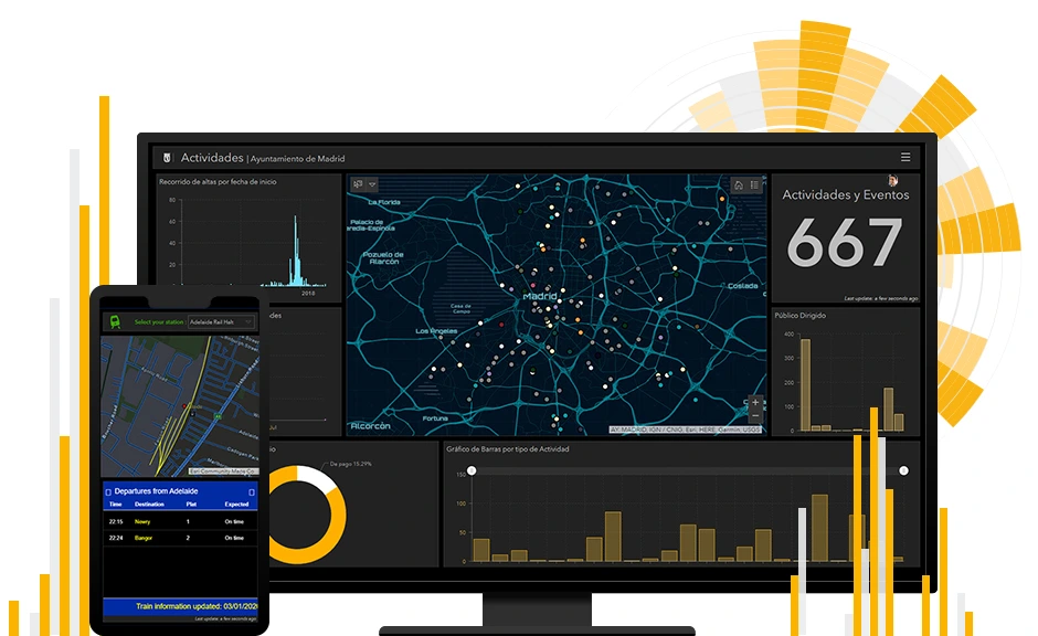
In an era where data drives decision-making, the ability to visualize and analyze information effectively is paramount. ArcGIS Online Dashboards, a product by Esri, provides a dynamic platform for organizations and individuals to gain actionable insights through interactive visualizations. As a GIS expert, leveraging this tool can revolutionize how spatial data is understood and applied. […]

Unlocking Insights: Exploring the Power of ArcGIS Online Dashboards Read Post »

Monitoring Holiday Travel
Blog

Monitoring Holiday Travel with GIS: Predicting Traffic and Managing Crowds

The Christmas holiday season is a time of joy and celebration, but for many, it also brings the challenge of managing heavy traffic and crowded transportation hubs. In cities like Abuja, Nigeria’s bustling capital, the influx of holiday travelers creates significant logistical challenges. This article explores how Geographic Information Systems (GIS) can be leveraged to

Monitoring Holiday Travel with GIS: Predicting Traffic and Managing Crowds Read Post »

Climate Change and GIS: Harnessing the Power of GIS to Tackle Climate Change
Blog

Climate Change and GIS: Harnessing the Power of GIS to Tackle Climate Change

Introduction Climate change poses significant threats to our global ecosystems, economies, and human well-being, demanding innovative solutions. To mitigate its impacts, Geographic Information Systems (GIS) technology has emerged as a crucial tool, enabling researchers, policymakers, and practitioners to analyze, visualize, and understand climate-related data, thereby facilitating informed decision-making to address climate-related challenges. This article explores

Climate Change and GIS: Harnessing the Power of GIS to Tackle Climate Change Read Post »

What is GIS?
Blog

What is GIS?

Geographic Information System is referred to as GIS. It serves as a framework for collecting, organizing, and interpreting geographic and spatial data. Spatial location—typically indicated by coordinates—serves as the primary index variable in GIS, which integrates a variety of data formats. Here are some crucial elements and applications of GIS:

What is GIS? Read Post »

Scroll to Top